Friday 28 September 2012

5 - Leith Hill, Surrey - 28th Sept 2012

Darwins Worm Stone
Stretching all the way from Farnham and across past Guildford, Dorking and Reigate stretch the Surrey Hills, A designated area of outstanding natural beauty, the highest point of these hills is Leith Hill, at 294 meters it is not only the highest point in Surrey but also the highest point in South East England.

Leith Hill is around a 90 min drive for me so I left home and drove through the towns of Petersfield, Midhurst, Petworth, Billingshurst and ended up parking in a National Trust car park below the Leith Hill.

My plan today was to follow one of the National trust trails to the top of the hill so I left the car park and walked into the woods following the path. The path actually started by heading away from Leith Hill but it soon curved round and through more woodland eventually coming out onto some open land, this was my first glimpse of the view south and even at the base of Leith Hill it was pretty good, It was also in this field that I found one of Darwin's worm stones, this is a large stone placed on the ground, worms would tunnel under the stone making it slowly sink into the ground, Darwin would come to Leith Hill and measure the rate of sinking and other measurements.

Further along the path, I passed Leith Hill Place, a rather impressive house hidden behind some trees on the slopes of the hill, this was once the home of Ralph Vaughan Williams the composer who handed it over to the National Trust in 1944 and it is now privately rented.

Leith Hill Tower
Further up the path I crossed a road and continued along past a walled garden and eventually along to another road and the first of the steps up the hill towards the top. The steps zigzagged up the hill for a short while and shortly came out near the top of the hill.

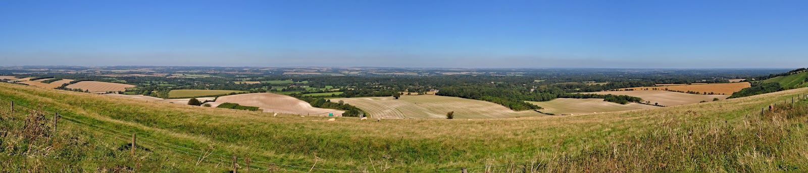
Standing on top of Leith Hill is Leith Hill Tower, an 18th century Gothic tower with panoramic views in all directions. The tower was built with the intention of raising the hill above 1000 ft and tower actually stands at a total height of 1029ft (329m).  To get to the top I had to climb 74 steps but it was worth it, to the south there were uninterrupted views of the South Downs and on a clear day you can see the English channel, then to the north lies London and I could easily make up the Shard and Wembley Stadium. Apparently on a clear day you can see up to 100 miles and 14 counties.

After climbing the tower I stopped for a cup of tea and flapjack from the little tower shop and I took some photos for a time-lapse movie. It was around this time the rain started but I managed to shelter my camera during its time-lapse and I had my new extra waterproof North Face all weather coat on so I was nice and dry.


Leith Hill Place
Finally it was time to head back home so I followed the path away from the top and down towards the car park, it was quite a short walk going back which was good as the rain had started to come down heavier, once I was back at my van and in the dry the rain suddenly cleared up and I headed off home after completing my visit to Leith Hill.


I highly recommend a visit to Leith hill as the views are stunning from the top and it makes a good free day out, the tower is £1-50 to climb or free for National Trust members but as I say it is well worth a visit.


Saturday 22 September 2012

3a - Black Down Revisited, West Sussex - 13th Sept 2012

I recently had a chance to revisit Blackdown, the highest point in West Sussex but this time at night, It was around 9:30 when I left home and the drive took around an hour, I drove to a different car park to the one I was at the last time as this one was closer and easier for me to walk up Blackdown in the pitch black.

I parked the Van in a very dark car park, and got my gear ready along with some torches and headed up the zig zag path to the top, it was easy to find my way up the path but it really was dark with plenty of noises, once I was at the top I set up my camera and started taking photos.


   The view was amazing, both of the sky and of the land spread out ahead of me, lots of little street lights and cars for miles around and millions or spots of light in the sky above, it is rare to see such dark skies.

I stayed up there for around 90 mins taking various photos of the nights sky and the view ahead of me. It was very peaceful up there as the wind was pretty much non existent, just the sound of the odd animal in the bushes around me (probably a bear or something). I think this is the first time I have ever managed to capture the Milky Way in a photograph so I was very happy with the results.

Eventually I made my way back to the car and drove back home, It was another very cool outing to the highest point in West Sussex.


Wednesday 12 September 2012

4 - Walbury Hill, Berkshire - 7th Sept 2012

Walbury Hill lies right on the border of Berkshire and Hampshire between the towns of Hungerford and Andover. It sits in a row of hills and other feathers which include Beacon Hill (Burial place of Lord Carnarvon of Tutankhamen fame) and Watership Down (of Rabbit fame).

Walbury Hill from Combe Hill
Walbury Hill is an easy 80 minute drive from my home along the M27, M3, A34, A303 and then the country roads through the villages of Enham Alamein, Hurstbourne Tarrant, finally up to the car park near Walbury Hill.

After parking my can it was a only short walk up to the top of Walbury hill but I had planned to walk much further, I left the car park and followed a very rough path down to a gravel track which ran along the side of a field where the high point was situated and this is where I noticed my problem, the field was full of sheep, now I have nothing against sheep but I did not know if I was allowed into the field, according to the map there was a small path to the highest point but the gate was locked and there were plenty of sheep in the way. I was not sure what to do so I decided to continue my walk.

Walbury Hill
I followed the path and eventually a sign appeared pointing across a field so I jumped over the stile and made my way along towards the next hill. While walking along the path I came across several signs to stay to the path as there were Lapwings nesting in the area, I never actually saw any.

Soon I was walking up a path towards the next hill where I managed to get some nice shots of Walbury Hill, It was along here I met the first flock of what I can only imagine was some kind of partridge, about 20-30 of them suddenly flew into the air making me jump. This happened around 10 more times during my walk, I estimate I saw several hundred of these birds, I would be walking along the path and then without warning they would erupt into the sky from just a short distance from my feet.

Sheep on the top of Walbury Hill
On top of the next hill I got some more great views of Walbury hill but it was now time to head back so I walked along another track which went down the hill and into some woodland, there were more partridges along here and a few of the fields nearby were being harvested nearby as well. Soon I came across another sign pointing back up the hill and just a few minutes up this path I came across the sheep, 20-30 of them all sat on the path ahead looking at me, there was no way to go around them and I needed to get by so I slowly worked my way through them, I felt like I was Moses parting the red sea of sheep.

At the top of the path I was back onto the original path across the top of Walbury Hill, so I walked back towards the hill for another look at the locked gate and field of sheep, there were defiantly subtle signs telling me to keep out, a massive padlock, a practically non existent path into the field, over grown shrubs making it difficult to get to the gate, a big sign telling me "BEWARE OF THE T-REX" , OK so I lied about that last one but I decided that this was as close as I was going to get to the top so I took a few pics of the sheep and headed back to the car for some lunch.

Field of Flowers
Back at the car park I had a look around, you can see for miles up here, below me the fields and forests run off towards the horizon and in the distance sat Newbury and Hungerford. I walked up to the next hill at this point, it was called Combe Gibbet and it had a wooden structure on top of it, it looked just like a telegraph pole but I have now discovered it was a gibbet erected in 1676 for the execution of George Broomham and Dorothy Newman, They were having an affair and when Georges wife and son discovered the pair together in the area George and Dorothy murdered both his wife and son. The murder was seen by a local and the pair were hung here to deter others from committing crimes.

I sat on top of Combe Gibbet and ate my lunch watching the world go by then after a while I set off home, while driving home I passed an amazing field of flowers, it was the most amazing sight, a rich purple colour, if it was a Dulux paint colour then it would be called Amethyst Showers (its true, look it up). I stopped at the field of flowers for a while and took some more photos, it was an amazing sight to see.


So I now come to the problem I knew I would get at some point during this blog, did I succeed? I never got to the top of the hill but that is because I couldn't get to the top. I did however get as close as I could, I guess as this hill is not too far from home I can always revisit and try again but I think I did as best I could, Its probably something I am going to have to get used to as there are plenty of other places I will not be able to get close to.


Looking north from Combe Gibbet


Sunday 9 September 2012

3 - Black Down, West Sussex - 5th Sept 2012

Just 1 mile south of Haslemere and close to the Surrey/West Sussex border lies Blackdown, at 280 meters it is the highest point in the county of West Sussex. This high point was going to be an easy one for me to get to as it was just a 45 minute drive away from my house in Portsmouth.

I left home with a packed lunch and set off up the A3 past Petersfield, through Haslemere and along Tennyson Lane to the car park at Blackdown. The land is owned by National trust so I planned a walk along the westerly edge of the National Trust land, then up the hill past a view point and back towards the top of the hill, then back to the car.

It was a rather beautiful day, clear skies with the odd cloud to add some interest and warm as well, I left the car park and followed the path into the woods which was made up of a mixture of pine trees, oaks, silver birches and other broadleaved trees, eventually I left the cover of the woodland and the path continues across some heathland where the heather was a lovely purple colour.

It was along this part of the path I first noticed the lack of noise, as there are few roads in the area it was very quiet, just the sound of the odd breeze in the trees and the birds in the sky, in the distance there was the sound of the occasional plane but apart from that it was very tranquil.
A Red Deer
Soon the path entered the woodland again and headed steeply down hill and through a gate, I was now out of the National trust land but it was necessary as just 30 meters along there was another gate back into the park heading back up the hill towards the top, the climb was not too steep, ahead of me on the path there were a few rabbits and also what I think may have been a hare.


Following the path I suddenly noticed something to my left me and there watching me was a red deer, this beautiful animal stood motionless and I slowly got my camera out to take a photo, its a shame I didn't have my zoom lens handy but I snapped a few shots anyway. Soon the animal moved into the woodland and then there appeared another red deer behind it and they both disappeared off into the dark of the forest.

The View from the Temple of the Winds
The Highest point in East Sussex
Soon after seeing the deer I made it to the top of the hill when I found a handy bench facing west at an amazing view, I didn't stay here too long however and continued along the path and finally coming out at a clearing which I later found out was called the Temple of the Winds. The view was magnificent, looking south east over the village of Lurgashall and across the south downs to the coast in the far distance. I have since found out that this place was a favourite place for Alfred, Lord Tennyson, he purchased Blackdown in his latter years and would sit here for hours getting inspiration for his work.

I sat here for well over an hour, eating my lunch and reading a book, I also set up my camera to take a time lapse movie (see below). After some time it was time to continue my walk, I still had not reached the highest point in West Sussex yet.


Walking away from the Temple of Winds and along a new path I reached a point just below the Highest point in the county so I headed off the main path and onto a small trail towards the point, I was unsure where the actual point was, maybe it was a hump here, or a mound over there? then suddenly I saw the Trig point marking the exact location, it was right on the end of the woods which was why I had missed it.

I did not stay too long at the Trig point, just enough time to take a few photos and have a small explore of the area, then it was back down to the main path to make my way back to the car park.
The walk back was nice and didn't take me too long, I stopped off to take photos at various times but I was soon back at the car.

The highlight of this trip was not the highest point in East Sussex but the Temple of the Winds with its magnificent views, I could have sat there for hours enjoying the sunshine and the peace and quiet. It is amazing to think that such beautiful places are right on my doorstep, I have recently found out that it is a prime location to view the stars at night so I will be returning at some point in the future to take some photos.


Saturday 8 September 2012

2 - Scafell Pike - 20-22nd Aug 2012

The Camp
Scafell Pike is the highest mountain in Cumbria, it also happens to be the highest point in England, I was to start this challenge with a nice memorable mountain to climb. Cumbria is a 6 hour drive from my home town of Portsmouth so it meant going for a few days rather than trying to get it done in one day. A camp site was booked and joining me were my friends Chris and Amy.


Chris and Amy


The drive up was uneventful, Chris and Amy were doing the driving for this trip and after a few pit stops along the way we arrived at our camp site in the Lake District ready to pitch our tents. The camp site was rather nice, the owners seemed very relaxed about everything and didn't seem to care when we pitched or what we did however it was a beautiful place to pitch out tents, just a short walk to the banks of Buttermere and surrounded by dramatic scenery, the perfect spot for a couple of nights.

The following day was the day of the climb and after a breakfast of bacon butties (thanks Chris) we headed off to Wasdale Head. Now the reason I chose the camp site at Buttermere was because it was a nice easy 9 miles away from the Summit of Scafell Pike, however due to the nature of the Lake District I did not realise that the 9 miles as the crow flies actually ended up as a 35 miles drive taking us well over an hour, oh well.

Wastwater

We arrived at Wasdale Head and first popped into the shop to get some supplies for the climb (mainly chocolate, drinks and fruit pastels for me) then we headed out of the village, down a road, across a field, finally over a river and we started our ascent, the path was ok, rough and covered in boulders but easy enough to follow. During previous climbs of Snowdon I remember it being pretty busy, especially when the weather was good there were a lot of people making the climb up Snowdon, however it was much quieter here, a few other people and a few families making the climb but not too many which was nice.

The Cloud
Eventually the path flattened out and curved around the hill where it followed a river and joined up with another path, after a section of rough path it was time to cross the river, there were no steps across, it was a case of finding the best place to cross on the assortment of rocks in the river bed.

After crossing the river the path changed from a path and into steps, they seemed to go on for ages, we climbed and climbed getting higher and higher, the view from here was spectacular, looking down towards Wastwater and beyond.

The Summit ( I am happy I promise)
After climbing steps for what seemed like ages it soon turned into climbing over rocks and boulders for a while, this area was apparently called Hollow Stones, there were plenty of stones to be found but I am not sure how many were hollow. Eventually the boulders turned into a pretty good path, probably the best path we had seem during the ascent, it was along this path we also met the cloud and a few more people. 

The Decent
The nice path did not last too long, it went back to a mixture of steps, boulders, rocks and gravel weaving its way up and up between and around larger boulders, the landscape made me think of the surface of another planet, strewn with an assortment of different sized rocks as far as you could see in the cloud. Finally ahead of us the shape of a summit appeared  through the clouds and we made our final ascent up to the stone structure on the top of Scafel Pike. 

Lone Traveller
At the top of Scafel Pike I have to be honest and say it was cold, really cold, having been climbing for the last 3 hours wearing t-shirt and we were were pretty warm but now we had stopped it got very chilly so out came the extra layers along with some lunch, it was quite cool to think that for the while we stood on the stone structure on top of the mountain we were the three highest people in England. 

We did not stay long at the summit, there were no views because of the cloud and no ice cream van 
either so there was no reason to stay and we started our descent of the mountain, as expected we were much faster going down. Re-tracing our steps we passed back down the rocky slopes of the mountain, along the winding path, past the Hollow Stones, down the steps, across the river again, around the hill and back town towards Wasdale Head.
Company along the way

I often have trouble with my knees when I do big climbs, I remember the first time I climbed Snowdon I suffered with bad aching legs during the last part of the descent and my knees suffered for many days after. So far this adventure had not affected my knees at all so I considered myself lucky with this one, the knee problems were to come a few days later but that is all part of the experience.

Back at Wasdale Head we headed into the village pub for a nice meal and a drink and Chris drove us back to the camp site, apparently he nearly fell asleep at the wheel several times but we got back in one piece VERY tired but a happy trio of climbers. 

The following morning we had a lovely breakfast, it was some kind of home made omelette (can you call it home made if we made it in a tent?) and headed out for a walk along the banks of Buttermere. After our walk we packed up camp and loaded the car up and headed off to the town of Keswick for a bite to eat at a tea room. 

After purchasing a Hedgehog (not a real one) and some things to eat it was up to Chris and Amy to drive us back home, I seem to remember sleeping for most of the journey (sorry).

The 3 day trip to the Lake District was amazing and to climb the highest peak in England was a brilliant way to start my new adventure.


Thursday 6 September 2012

The Plan

Ever since I was a kid I have loved the great outdoors, as a youngster the annual holiday was usually a camping trip to the New Forest or the Isle of Purbeck. In recent years I have had a yearning for doing something interesting.

Rob, Clint and Chris on Mount Snowdon - November 5th 2009
I have climbed Mount Snowdon twice in recent years, both climbs turned out to be very different, I first climbed to the top of Mount Snowdon with Chris and Clint on the 5th November 2009, it was cloudy, it rained most of the day, it became very windy and freezing cold during our ascent and towards the top the cloud became so thick it was tough to see the path ahead of us, this made it VERY memorable and a real adventure.


Chris, Amy, Nat and Rob, Mount Snowdon - Septermber 2010
The next time I climbed Snowdon was in September 2010, this seemed like it was a totally different mountain, I was joined by Chris, Amy and Nathan. The weather was hot, sunny, beautiful blue skies with the odd fluffy cloud to add some interest and the views were spectacular, The weather actually made it harder to climb as we kept having to stop for drink breaks and rests, also you must stop and take in the views once in a while so the climb took us a lot longer this time, it was an amazing climb.


So for some time I have had the idea of visiting the highest point of every county in England (and maybe even Wales and Scotland eventually). Some of the places I would need to visit would be rather difficult to get to, for instance some are on private land, because of this my plan is to get as close as possible to the highest point. Other places will be very easy, the highest point of the City of London is High Holborn, a very grizzly 100 meter walk from Holburn Tube station, I will however try to make the easy trips more interesting somehow.
The visits will develop with time, I will find new places to climb, If I stick with English counties there will be 48 in total, however if I add in all the other city boroughs (for instance Portsmouth and Southampton are both separate from Hampshire) then the list goes up to 121, add in Wales and it goes up to 140. 

So here it is, the photos and the stories of my visits to the highest points of every county in England (and maybe more).

Enjoy

Rob