Monday, 8 August 2016

121-122 - York and Barnsley - 14th-17th September 2015

Highest point of Barnsley
In September 2015 I was heading up to Leeds for a work event so while in the area I thought I would tick off a few more high points. first was the highest point of York,

Stock Hill
I was staying not too far from Wetherby and the highest point of York was not too far away so I headed off and parked nearby. There was not much of a walk to the highest point and I found it quite soon, not one of the most exciting high points around but still good to tick it off my list. The highest point of York, Stock hill and the crazy height of 44mt.

Endless moorland
After my work event I stayed at a campsite near the town of Penistone, a very small but lovely and friendly campsite called Orchard Camping. It had a fire pit everyone was so friendly, well worth a visit. The next day I headed off to find one of my high points, it took me a while to find somewhere to park as the road was very busy, I managed to find a layby on the A628 to pull over into and I headed off across the moorland on a rather gloomy day. The ground was very wet underfoot (really much buy new hiking boots) and after a while of trudging across the moorland I arrived at Hoar Stones, at 514 meters it is the highest point of Barnsley, I didn't stay too long and soon I was retracing my steps to get back to my car and back to my campsite where I enjoyed a delicious stew cooked on the campfire.


120 - High Willhays - Devon - 11th August 2015

Meldon Dam
Devon is a beautiful county with some amazing countryside and towns, it is also home to Dartmoor, a National park and huge moorland, the location of the highest point of Devon. for this trip I was accompanied by Chris G and he set off from Bournemouth arriving at our campsite on the edge of Dartmoor near the town of Okehampton in the Appledore farm campsite, a lovely and friendly campsite.

On the day of the walk we parked in a car park and headed off to find the high point, the first thing we arrived at was the Meldon Reservoir, our route took us straight across the dam and there were some impressive views both across the water and then down into the valley below. Once across the dam we started to make our way uphill, first walking up and around a smaller Longstone hill and then up Okehampton common. It was very wet and boggy underfoot and my feet were soon drenched (must buy new hiking boots). but soon we were working out way up the slopes to Yes Tor.

From Yes Tor it was a fairly flat walk to High Willhays, at 621 meters the highest point of Devon. We stopped here for some lunch and a cup of tea and then we made our way back down the slopes along a different route. from High Willhays we walked down the north east slopes and then up West Mill Tor for another short snack stop and then down the western slopes across Black Down. This whole area is used as military training grounds so there were signs of military life popping up at various times, small huts and even a railway.

High Willhays
We eventually left the moorland passing through a car park and then had to climb uphill again to an old railway line and the Meldon Viaduct, We crossed the bridge and then made our way back to the car tired and happy after a successful hill climb.

During the rest of our stay we decided to do a few more walks, one was when it was very wet and we headed off into a misty forest to try and find some shelter from the rain, it was a lovely walk and quite a spooky atmosphere. Our second walk took us down some country paths, it also featured us getting a bit lost, discovering some abandoned vehicles, having to climb our way through the soaking wet undergrowth and into a farmers field and then trying to find our way back to the car  while trying to avoid walking across anyones private property (Thanks Chris ☺).


All in all it was an excellent few days and a successful hill climb. I think this hill was my halfway point in my highest points challenge. 


Cowpat Mushroom


Thursday, 4 February 2016

117-119 - Wirral, Halton and Warrington - 30th July 2015

The area around Manchester and Liverpool is full of highpoints to visit so I decided to start ticking those off while combining it with a visit to see a friend who lives in the area. Robin is a fellow entertainer and marathon runner, he lives not too far from Chester so I made plans with him, he offered to give me a lovely guided tour of the city.


Chester really is a lovely place, Robin took me on a walking tour to see all the highlights including the walls, the cathedral, the Roman amphitheatre & gardens and the River Dee. We made use of the park and ride which was an excellent service and spent several hours in the city. The Cathedral was amazing and well worth a visit, they had a themed walk around the buildings based upon the stories of Alice in Wonderland. Away from the cathedral I really liked one of the foot bridges over the River Dee, it was a suspension bridge and was very photogenic. The visit to Chester was finished with a nice cake and cup of tea in the top floor cafe in Debenhams.

Poll Hill
The first of my 3 high points we to be found in the Wirral, I can't say that any of the high points in the area are phenomenal and the Wirrel is the least exciting of the 3 as it was basically a footpath and small green area in a residential part of the area. This was called Poll hill and was 108 meters above sea level.

Halton Castle
Next up was a short drive to Halton, this high point was a little bit more impressive as there was a ruined castle here, it was not as high as the Wirrel however it did have a better view over towards Liverpool, At 100 mtrs Halton Castle was the highest point of Halton.

Another short drive and I was now in Warrington, this one was a tough one as the highest point was situated in the middle of a private gold course, I tried to find a way to get to it however it was not looking good to I drove around and eventually got as close as I good with another lovely view over towards Liverpool, this one was called Appleton Park and at 105 mtrs it is the highest point of Warrington.

Appleton Park
So that is 3 more high points ticked off and although they were not too exciting I did manage to get a great guided tour of Chester, Thanks Robin.

Monday, 1 February 2016

116 - Kinder Scout - Derbyshire - 9th July 2015


Soon after returning home from the Channel islands I was off once again on another mission to tick off another high point from my list and this time I was to be accompanied by Chris. Chris lives in Bournemouth so I drove down to pick him up and then headed north to the Peak District in Derbyshire. Our campsite was situated in the small village of Hulme End in the south of the Peak District not too far from the town of Ashbourne, It was a lovely campsite on the edge of a hill and we pitched up our tent right next to the river Manifold. It was not long before we were visited by lots of ducks.

We had 2 whole days spare in the Peak District and were wondering what to do on our first day, after a bit of exploring and research we discovered there was a walking trail in the area called the Manifold Trail, it would involve a few buses but we thought it would be great to walk the entire length. The Manifold trail is a 9 mile walk that follows an old steam railway along a river and through various valleys and past many other features such as caves, farms and old mines.

We caught the first bus right from the entrance of the campsite, this took us to the town of Ashbourne where we had a quick wander around and we got some lunch to take with us, then it was bus number 2 which took an odd route through some country lanes to the small village of Waterhouses which marked the starting point for our walk back to the campsite.

The walk was really nice, as it wound through the valleys and along the river, it was very green, I think there had been a lot of rain and as it was July there had been a lot of growth recently. The walk went over a few bridges and we were passed by a few people and cyclists but not many, it was nice for it to be so quiet. The path also passed below a few caves including Thor's cave, a natural cavern used by ancient humans to live in. Eventually we came to the half way point which was marked by a little tearoom where we stopped for a drink and snack.

Moving on we carried on along the Manifold way, being an old railway line the trail was very flat so it was an easy walk, the trail also went through a very long tunnel which was cool. Eventually the trail took us into Hulme end where we found the original station still being used as a tourist information centre and a cafe. We ended the day with a relax and a nice dinner.


The next day it was time to tackle the high point of Derbyshire, it was a 40 minute drive but the scenery was lovely and we arrived at a car park not too far from the village of Edale. Leaving the car we headed north and along some roads and onto the pennine way which took us past a farm and along a valley. Crossing a river we were now starting to climb and the first part of the climb was called Jacobs ladder, a steep series of steps which helped us gain some height quite quickly. We were now high up on a ridge and up until now it had been quite quiet but we now came across some larger groups of people heading in the other direction so we pulled over to one side and let them pass.

Carrying on upwards we arrived at some rocky outcrops where we stopped for some photos and then we made ur way onto the the top of Kinder Scout. Here is where it gets complicated, Kinder Scout is the highest point of Derbyshire however the top is so huge and so flat it is difficult to know where the actual highest point is, I had a rough idea so we headed across the marshy land and found what we thought was the highest point and took some more photos, The highest point is 636.3 metres above sea level.

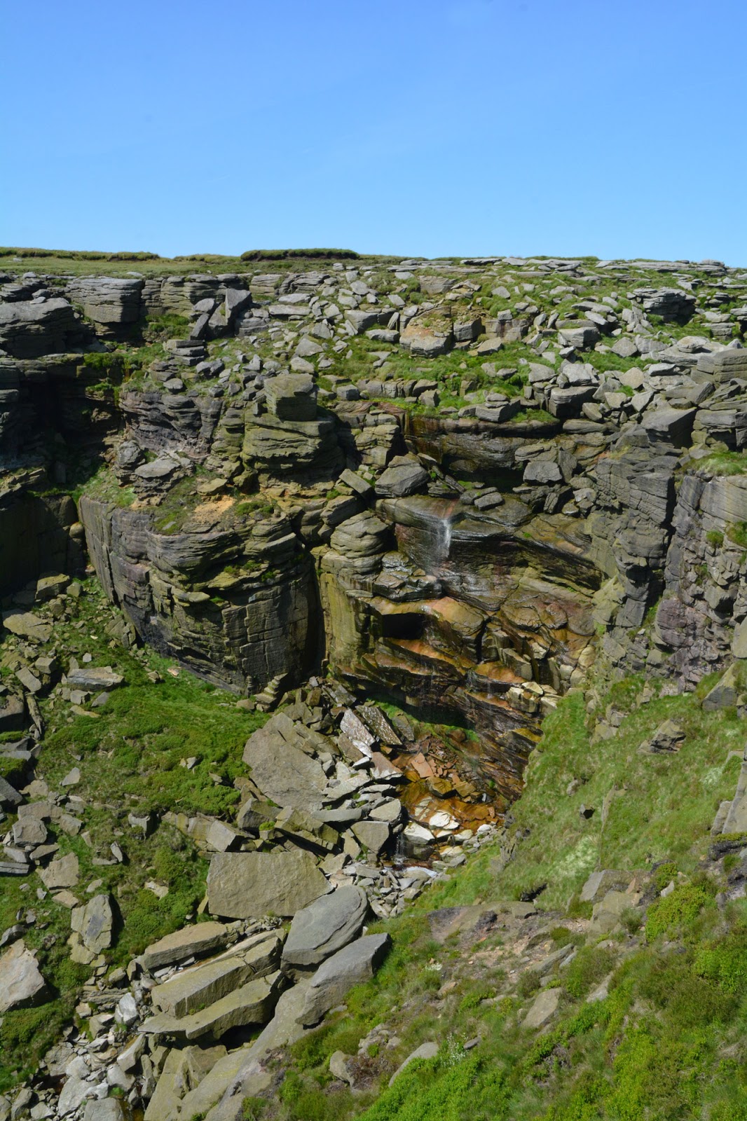
From here we had decided to do a circular walk around the top of Kinder Scout so we headed off again around the edge of the huge top plateau. We stopped for lunch for a while and then moved on to find an amazing waterfall cascading down the side of Kinder Scout, We walked to the top of the waterfall and found the river and amazingly the water was really warm, it was almost bath temperature. Instead of following our planned route we decided to change our plan and follow the river across the top of the mountain. this was quite strange because as the whole area is very soft and peat-like any running water creates hundreds of mini deep valleys all over the top of Kinder Scout.

We followed some of these valleys for ages, they were all roughly 8-12 feet deep and we followed them for ages not really knowing which way we were going however we decided to climb up one of the valley walls so we could see where we were. Once we were able to see our location we found we were still quite a way from the way down from Kinder Scout, it took a while to work our was across to the main path that runs around the top of the mountain and then we decided to take a much more exciting route back to the car.


The route we had decided to take took us straight down to the car in a fairly straight line however the path was pretty much vertically down another waterfall, This was a bit worrying at first because as we stood on the edge looking down we couldn't actually see where the path went below us. it was slow climbing but we found the path down and it was probably one of the most exciting paths I have ever taken. Looking back up at the route behind us we both couldnt believe that we had climbed down it. From here it was a fairly flat walk along a small stream and then back to the road and back to the car.

That evening we had a meal at a local pub and then had another rest at the camp site before our long drive back home the next day. It was an excellent trip and the Peak District is an amazing place, Kinder Scout is well worth a climb as it is a fascinating place. Thanks Chris for an excellent few days away.

Friday, 29 January 2016

115 - Les Platons - Channel Islands - 1st July 2015

There is an official list of high points in the UK and as you may know I have added a few honorary high points along the way, such as the Shard in London, It was time now to do another honorary high point and there is a reason why I needed to do it. The Channel Islands are a group of islands about 90 miles directly south of Weymouth and roughly 10 miles west of France, it is not listed amongst the list of official UK high points for the same reason that Gibraltar and the Falkland Islands are excluded, I do however have a link to the islands as my family comes from Jersey, I still have family on the island so it would be a shame not to visit the highest point during a visit to see my 95 year old Grandma (actually she will be 96 in the next few days (Happy Birthday Nan)) and my Auntie and cousins.

A first for this blog is a plane trip, I travelled from Southampton to the island of Jersey where I was collected up by my lovely Auntie Caroline, she would also be putting me up for a few days at her home in St Clement in the south west of the Island.

The day of the hill trip arrived and I was left to my own devices all day as my auntie had some errands to run, so I wandered to the bus stop and caught the bus into St Helier where I changed for another bus which took me north to a remote bus stop on the side of a road in the north of the island.

The bus dropped me off pretty much exactly where I needed to be, at 136 metres (446 ft) Les Platons is the highest point of Jersey and this became pretty obvious when you see all the various radio towers and masts in the area. I didn't wander around too much here, I didn't know how much was private land and there were people around so didn't want to trespass so I took some photos as close as I could and then wandered down the road to a car park. 

I had decided on the previous day that I was going to start at the highest point and work my way down to the sea so I found a footpath and wandered along it towards the sea and the cliffs, eventually I came out at a house right on the edge of a cliff and below me I could see my destination, the beach at Bonne Nuit bay. From my location at the easterly end of the beach I had to walk along a few paths and past some houses to the opposite end, here there was a small tidal harbour (the tide was out) and a small cafe. It was time for lunch (crab sandwiches) and a sit on the beach for a while, I had some time to kill as the bus from here was once every hour so I sat on the beach and enjoyed the sunshine. 

All that was left to do was to get back to my aunties house so I eventually caught the bus back into St Helier where I decided to have a wander around town for a bit then I walked back the 2 miles to St Clements and my aunties house. The rest of my time in Jersey was filled with swimming in the sea and more crab Sandwiches which are lovely. Thanks to the weather my visit to Jersey was AMAZING and I look forward to returning again soon. 


Tuesday, 18 August 2015

111-114 - Parts of East Anglia - 23rd to 25th June 2015

Cromer
There are a several of my highpoints which always cause people to ask questions and it tends to be those in East Anglia, The reason is the fact that most of East Anglia is as flat as a pancake but even the flattest places have high points so it this was my opportunity to get those ticked off my list. I travelled up from my home in Portsmouth and around London heading for my first or 4 high points. the county of Suffolk is divided into 2 halves, there is Suffolk and Suffolk East. Eventually I was onto the country roads of Suffolk and I arrived at my destination. It was actually difficult to get close to the highest point of Suffolk East because it lies within Wattisham Airfield, as you can imagine airfields are always difficult to gain access to however this one is even worse because it is an Army airfield so there was no hope.
Wattisham airfield

I found spot near an industrial estate near the Wattisham airfield fence, this spot was about as close as I could get to the highest point of Suffolk East so it would have to do and at just 91 metres above sea level I was not really going to be that far off that height from where I was standing.

Great Wood
Next stop was the highest point of Suffolk, it was about a 45 min drive from the last stop along some pretty bendy small roads. It was fairly easy to find and finally I found myself at Great wood near the village of Chedburgh just to the south of Bury St Edmunds. This was another fairly low high point at just 128 metres above sea level, at least this one had a view over some fields. My next stop was my campsite for the night which was about a 90 minute drive to the north near the town of Sheringham on the north coast of Norfolk.

Great Wood
The next day I was off to find my third highpoint of the trip, this one was going to be the highest of my 4 highpoints and it can be found just near the town of Cromer and is the highest point of Norfolk, It was another easy to find high point and is called Beacon Hill, it has fairly impressive views over the sea which would be even better in the winter without all the leaves on the trees. I had a bit of a wander around here and eventually headed into Cromer for a look around and then on to Sheringham for a trip on the North Norfolk Steam Railway (well worth the visit by the way, I really recommend it). Finally it was back to the campsite for an evening next to the campfire.

Beacon hill
The next morning it was time to head home but there was one more high point to visit on the way, I took a small diversion towards the west and then south towards Ely for the highest point of the Isle of Ely. The Isle of Ely is not actually an island however it was surrounded by fens and marshland in the past so was once an island, it is no longer a county however it is still on my list and needed to be done.

On the way to the high point I suffered a bit of a puncture however I quickly changed it for the spare and was back on my way to find the high point in the village of Haddenham. This high point is one of my lowest yet at just 39 metres above sea level. I was surprised it was so low being so far inland. after stopping off here is was back on the road to home after a nice few days in the northern parts of East Anglia.
Cromer Pier
Haddenham village