Sunday, 29 September 2013

65 - Wentwood - Newport - 1st August 2013

I was on day 3 of my trip to Wales to climb a few highpoints and today was the day I was due to travel back home again. It had been a went night but by the time I had woken up the next morning the sun was out and it was now a glorious sunny day so I was able to pack away while drying everything out at the same time, this included both my cameras (not good) and most of my clothes which had gotten wet the day before, thankfully it all dried out quickly and both the cameras still work perfectly.

Once I was all packed up I left the campsite and made my way from Pencelli Castle south towards Abergavenny and then on towards Newport, before I reached the M4 I turned east and drove for about 20 mins until I reached a car park not too far from today's high point. This was Wentwood, a large area of ancient woodland in Monmouthshire and not too far from the Welsh/English border.

I left the car in the car park and walked into the woodland along a rather large path, this path soon turned out to be the main road in and out of the woodland for some tree felling work going on but I managed to avoid all of the machinery. I soon left this main path and took what looked like a really old path further away from the main path.


Eventually after a few turns and other paths I reached an area which was the highest point of the unitary authority of Newport, it was only a 20 min walk from the car park but I didn't have too much time and I had a lot of travelling to do. I stayed around here for a while and had a bite to eat but It was not long before I wandered back to my car.


Once I was back at my car I drove the rest of the way home after an excellent few days of climbing, camping and high points.


Sunday, 22 September 2013

64 - Pen y Fan - Powys - 31st July 2012

Pen y Fan is not only highest point of Powys but also the highest point of the Brecon Beacons, the highest point of South wales and it is the highest point in southern UK, I knew this was going to be a challenge.

This was not my first visit to Pen y Fan, I visited the Brecon Beacons when I was 15 and climbed the mountain then, I remember it well, it was very hot and very sunny, today however was going to be quite a different climb. The Pencelli Castle campsite where I was staying was about 7 miles away from the top of Pen y Fan so I decided to walk all the way, I left the campsite around 10am and headed out of the village and past the Monmouthshire and Brecon canal.

After passing through the very quiet village of Llanfrynach I left the road for the first time and headed cross country along some footpaths and down by the side of a river, up until now it had been very dry but the rain started to fall and so I got the waterproofs out and carried on. After following the river for some time I veered off and headed across some fields, apart from passing the occasional farm worker I saw no one, it was very quiet and rather nice to have such peace and quiet, its not often we experience that in this modern world we live in. Eventually I walked through a farm and I was back on the road for the next mile or so.

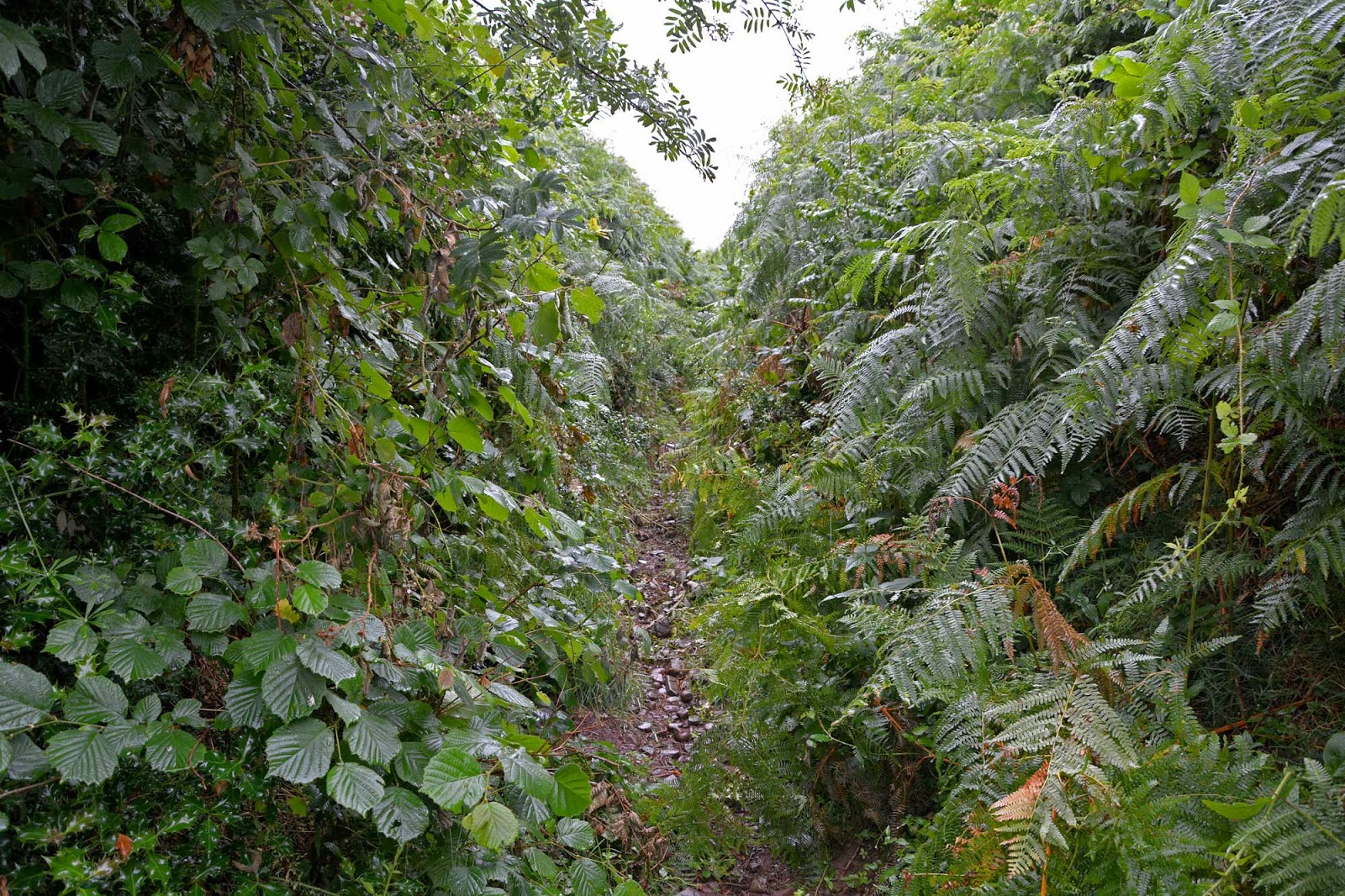
The road zig-zagged its way through the fields and over rivers (and waterfalls) and I soon turned left down a smaller road finally heading towards the mountains. The path ahead was clearly marked on my map, a nice straight pathway leading to the edge of the Brecon Beacons national park, easy I thought, however when I reached this path I found it was badly over grown, I couldn't see very far along the path and I didnt really know what to do, if turned back it would add a mile or more onto my walk, if I carried on there was no guarantee I could find my way along the path.

I decided to try the path, the rain had stopped and I was after adventure so I headed along the path. I had managed up until this point to stay relatively dry from the rain but after about 2 minutes of walking along this path I was soaked, the ferns on each side of me were wet and I was getting wet from the plants above and below, not only was I trying to avoid getting too wet but I was trying to avoid the stinging nettles, thorns, bramble and almost every other type of attacking weed you can think of.

It took me about 30 minutes to navigate this path, by the time I had reached the end I was soaking wet, scratched and stung on my legs, also I was worn out from climbing my way through the undergrowth, it was a bit like working my way through a jungle and think I could have done with a machete. I had finally reached the gate onto the Brecon beacons national park so I stopped for a few minutes and had a bit of tea from my flask, changed some of my clothes for dry ones and headed through the gate and up the first major slopes towards the top of my first mountain of the day.


The climb upwards started almost immediately, there were a few sheep around and the path worked its way up, the cloud was thick above me and the rain was back again along with the wind, I could tell I was getting higher. Very soon the path had taken me up into the clouds and the visibility was down to about 50ft. There were a couple of people heading in the same direction so I walked along with them for a while and kept them in sight, After about 30/45 mins climbing the path suddenly took a change in direction, not to the left or right but vertically, it had been a steady climb so far but suddenly it changed to a very steep climb, I was having to clamber over boulders and work my way up steep steps.

The Summit of Cribyn
I eventually reached the top of this first mountain, this was Cribyn, a typical looking mountain with a pointy top, at 795 mts high is was not my final high point but it was still excellent to get to the top, The wind here was really strong so I didn't stop, I carried on to my next mountain and highest point. The Path from the top of Cribyn went back downhill immediately but not for too long, it soon became a flat path for a short while and after crossing a small marshy area it started to head uphill again. The path weaved its way around large boulders but it was not as steep as the path up to the top of Cribyn, it was still a tough climb though, It was along this path I passed 3 other people going in the other direction, these were the only 3 people I saw on the slopes on Pen y Fan.

The Summit of Pen y Fan
I soon reached the summit of Pen y Fan, it is 886 meters high and the weather was crazy at the top, the wind was so strong and it was mixed with rain so I took a couple of photos and then managed to find a sheltered corner among some boulders where I could have a cup of tea and a bite to eat. I didn't stay at the top long as the weather really was horrible so I headed back down the slopes of Pen-y Fan along a path that would take me back down without having to climb Cribyn again.


The path from the top of Pen y Fan took me along the top of some pretty cool ridges, sadly I couldn't see too much as the cloud was obscuring my view, it was not too long before I was back down out of the bad weather. I worked my way back down the path over a few more hills and past the sheep and around the edge of a final hill, finally coming out of the National park and back into the farm land and countryside of Wales.

After leaving the national park I headed through a farm and along a few roads and then I was back on the same roads I used earlier in the day, all I needed to do was retrace my steps back to the campsite and back to a nice hot shower, dry clothes and a lovely barbeque and relax.

This climb was amazing, I couldn't see much of Pen-y-Fan but it was still an awesome climb and one I will remember for a long time. 

Tuesday, 13 August 2013

62-63 - Merthyr Tydfil and Caerphilly - 30th July 2012

This week I had decided to head back to South Wales to climb 4 high points, I was camping again and headed off to a wonderful campsite a few miles south east of Brecon called Pencelli Castle. I arrived early afternoon and set up my tent and base camp for the next 3 days, it was a beautiful sunny day with just a bit of cloud, perfect camping weather.

After setting up my tent I headed towards Brecon and then down through the Brecon Beacons along the A470 to Merthyr Tydfil. One of the most difficult things about my the high points tody were finding somewhere to park, I started off not too far from the Brecon mountain railway but could not gain access to the area I needed to climb from here, next I stopped at the village of Pant, after a short walk I found there was a farm in the way with no access through to the high point.

The next place to stop was a small road to the east of the high point but there was no area to park and it did look like private property, finally I parked on the side of a road near 3 horses and a gate giving me access to the area I needed to climb. I passed through the gate and past the horses and slowly climbed up towards a reservoir, it was actually a pretty hard walk to start with as the ground was so uneven and the paths were pretty non existent, I did manage to find a few sheep trails to follow but it was not long before I had reached my high points.

Now because of the way the borders are in this area there are 2 high points very close to each other, within a matter of minutes I had visited both of them, the disappointing thing however was that because a third border runs through the area none of the high points were actually on the highest ground in the area, so there I was standing half way up a hill on the highest point of the Unitary Authorities of Caerphilly and Merthyr Tydfil.


The walk back to the parking spot was uneventful until I met the horses again and they seemed to take a liking to me and followed me all the way to the gate, then it was back to the campsite for my first camping dinner of the week.

Both Merthyr Tydfil and Caerphilly High points were rather disappointing due to the fact that there was much more amazing scenery just a short distance away however I am pleased I did it and it was worth the relatively short walk.

Monday, 29 July 2013

61 - Chwarel y Fan - Monmouthshire - 3rd July 2013

It was time for another climb on this short camping trip away and I headed out of the campsite and back past Black mountain (the subject of yesterdays climb) and down the gospel path to the tiny village of Llantony. I parked in the car park next to an old yellow car and took a quick look around Llantony Priory, a partly ruined Augustine Priory. The Priory is now the sight of a small b&b and a campsite.

After the quick look around the priory I headed off through the village and down to the river where I had to find the bridge to cross over, I asked directions and found the little bridge to cross the river. The path went along the edge of the river for a short distance and then headed up a valley and over a few styles and through a few fields of sheep. Eventually the path left the fields and became steeper, it was totally surrounded by ferns and was a rea
lly pretty walk.

It was along this part of the path that I discovered a lady looking for her friend, he had gone wandering off to find the correct path and she had lost him, anyway, I said I would look out for him, about 20 mins later I eventually saw him, walking back down the path, he had no map and mobile phone, and he had not a lot of idea about where he was going but he was soon reunited with his friend. Its crazy to think how easy it is to get lost on the mountains with no maps or communication.

I carried on climbing up the mountain and eventually reached another path heading north/south along the tops of the mountains, there was a big pile of stones here but I still had a lot of walking to do. The route I took now headed north and I had another steep climb to do and eventually I made it to the top of Bal Mawr, it was now a fairly steady and lever walk of nearly 2 miles to the highest point.

After walking for about 40 mins along the tops of the mountains I eventually arrived at the highest point, at 679 meters (2228 feet) Chwarel y Fan is the highest point of Monmouthshire. There were rather amazing views from the top, to the north east was Black Mountain, the subject of my last high point and then to the west were the rest of the B
recon Beacons. I stayed on the top for about half an hour while I had a cup of tea and some lunch and then it was time to retrace my steps back down the mountain and back to the car park.

The walk back was rather uneventful, apart from passing 2 people climbing up the mountain I saw no one else for the walk back down and I was back at the car in around 90 mins. Chwarel y Fan was an awesome climb and the views were spectacular, with plenty of other mountains in the area it was a brilliant climb. Once I was back at the car I headed into Hay and Wye for a quick look around and then I was back to the tent for my last night of camping.


Wednesday, 17 July 2013

60 - Black Mountain - Herefordshire - 2nd July 2013

It has been a fairly long time since my last visit to a high point, I have recently tried to visit a high point but this had to be cancelled at the last minute due to no fault of my own, as you can imagine I have been itching to get out there and get a high point done, especially after having a trip cancelled, I was ready for an adventure.

Black mountain lies right on the western edge of Herefordshire on the border of Monmouthshire and on the eastern edge of the Brecon Beacons. I left home early in the morning and drove the 169 mile routh along the M27, M3, A34, M4, then various roads past Cirencester, stopping off at Gloucester for some lunch, then past Ross on Wye and through Hay on Wye arriving at the Lower Porthamel campsite near Talgarth not long after lunch.

Lower Porthamel was to be my base for 2 nights and it was a beautiful place to stay, it has 2 camping areas, the open field which has amazing views of the rolling countryside and mountains, then there is the lower Orchard, a smaller (but still spacious) area next to the farm house and duck pond. As I was the only person staying on the campsite I had a free choice of where to set up camp so I chose the Lower Orchard as it was closer to the toilets.

The Gospel Path Road
Once I had set up camp and had a cup of tea it was time to tackle Black mountain, it was roughly a 30 minute drive to the parking spot for Black mountain and most of this was along tiny country roads. The parking spot was on the Gospel Pass, a road which winds through the mountains. I parked up and set off, the weather was cloudy and a little windy but not too cold, It looked like it would rain so I had my water proofs with me.


Lord Herefords Knob (or Twmpa) 
After leaving my car I almost immediately started climbing a steep hill, I climbed this for about 15 mins and it was the steepest part of the walk for me quickly getting me to a higher altitude where the views became amazing, I could see for miles in a north westerly direction over Hay on Wye and beyond. once at the top of the steep path I continued along in a straight northerly line for a while coming to a Trigpoint on the path, this marked the summit of Hay Bluff and my first encounter with the Offa's Dyke Path.

The Offa's Dyke Path
The Offa's Dyke Path is a 176 mile path running along the ancient Offa's Dyke and along the border of England and Wales from Sedbury near Chepstow up to Prestatyn on the North Coast of Wales, From the Trigpoint I joined the Offa's Dyke Path and I headed off in an easterly direction, up until now all of my walk had been in the county of Powys in Wales but I was now walking along the Welsh Border, and along the border of Herefordshire.


It was around this time that the cloud began to thicken, not above me but all around be, the Path was very easy to follow so not a problem but I couldn't really see too far ahead, just the odd glimpse when the cloud thinned a little. The path was slightly raised and on either side there were pools and marshes, it was like being in a Tolkien book.

Soon I came to another steep climb and a group of horses blocking the path, I walked around them and climbed to the top of this next steep path, this was now Black Mountain, The summit of the mountain was another 5 mins walk along the path and it was right at the summit I passed the one and only other walker of the day, he appeared like a ghost out of the mist ahead of me, we said hello and he disappeared into the mist behind me. The summit was a fairly flat area, a few marshy pools and lots of little white flowers, I sat here and had some sandwiches and a cup of tea then I headed back to my car along the same route.

Highest Point of Herefordshire
The journey back was uneventful, the horses had all gone and were now replaced with sheep, I stopped off to take some photos and to do a timelapse of the amazing views, then it was back down the steep hill to my car parked on the Gospel Path.

Back at the Campsite I enjoyed my dinner of barbecued sea bream and pasta then I was off to bed to be ready for my next climb tomorrow.


Dinner

Sunday, 5 May 2013

59 - Milk Hill - Wiltshire - 3rd May 2013

Milk hill sits amongst a small range of sweeping hills just a few miles south west of Marlborough, this hill was not going to be a difficult one to visit but it was going to be interesting as Milk hill is regarded as a bit of a celebrity due to its links to UFO sightings and frequent appearances of crop circles, it also has a rather cool feature carved into one side but more about that later.


The drive to Milk hill took me about 90 minutes from Portsmouth, driving up the M27, M3, A34 then along the A303 to Andover. after coming off the A303 I took the smaller roads through the villages of Ludgershall, Upavon and Alton Barnes finally arriving at the car park.


Leaving the car park I walked across the road and through a gate, heading south west I passed through the first of many fields full of sheep. Through another gate and yet another gate I was now on open ground and I followed a path over some ancient earth works and up the first of today's hills, this hill is called Walkers hill and already the views on this walk were magnificent. Standing on top of Walkers hill I could see for miles towards the east, south and west, below me sat Alton Barns and in the distance were Upavon and the village of Pewsey. I took some photos here and soon moved on.

The path now took me west and soon I was in sight of the feature I had mentioned earlier, a giant white horse carved into the side of the hills, the horse is a rather nice looking horse, very bright in the sunlight, the path took me right over his back and past his ears, I have never been so close to a white chalk horse before, after passing the horse I entered into another large open area full of sheep.


I stopped off in this field to take a few time lapse movies and have a cup of tea while still surrounded by sheep, there were a lot of paragliders using the hills and a take off point so I watched them soaring overhead, I found it amazing that there could be so many in the sky and they never seem to collide.

After my flask of tea I moved onwards to the actual highpoint, it was situated in a field so had to nip over the fence briefly to get a quick look, Milk Hill is the only one of my high points with a point of a meter in its height, this is because neighboring Tan hill is roughly the same height (294mts) and for years it was unknown as to which was the highest, so the TV program Country File conducted a survey and it turns out that Milk Hill was 25cm higher, so I was happy to conquer Milk Hill at 294.25 meters. I didn't stay long as I was not sure if I was allowed into that field so I made my way back to the main path and headed north and then east around the edge of the field.

Soon the path started to slope back downhill and it was not long until I could see the car park in the distance, I still had to head through 2 more fields of sheep and across the road and back to my car. Before I left the area I drove down to the base of the hill under the white horse to get a few more photos.


Milk hill is in a beautiful part of the world and I really recommend a visit, it is not a difficult walk and the views are stunning so get out there and explore the area.


Here is the time lapse video I shot around Milk Hill -
http://www.youtube.com/watch?v=kcVwy-UOLnc&feature=youtu.be

Wednesday, 1 May 2013

The Story So Far

Here is a list of all the high points I have visited so far on my quest in the order I visited them.

The best climbs so far are either Snowdon in Gwynedd or Worcestershire Beacon in Worcestershire. 
The most disappointing high points are either Telegraph hill in Kingston or the Vale in Hounslow.

Total visited so far 58 (out of 236)
Percentage visited 25.22%
Combined height of visited high points in meters - 11109
Combined height of visited high points in feet - 36447
Combined height of visited high points in miles - 6.902


NameCounty/UA  MtsFtDate Visited

Snowdon - Yr Wyddfa Gwynedd   1085 3560 02 September 2010
Scafell Pike Cumbria   978 3209 21 August 2012
Black Down West Sussex   280 919 05 September 2012
Walbury Hill West Berkshire   297 974 07 September 2012
Leith Hill Surrey   295 968 28 September 2012
Ditchling Beacon East Sussex   248 814 03 October 2012
Corfe Hills Poole   78 256 10 October 2012
Ringwood Road Bournemouth   65 213 10 October 2012
Pipers Wait New Forest National Park 129 422 10 October 2012
Basset Avenue Southampton   82 269 10 October 2012
Fort Southwick Portsmouth   122 400 10 October 2012
St Boniface Down Isle of Wight   241 791 22 October 2012
Ebrington Hill Warwickshire   261 856 06 November 2012
Rednal Hill Birmingham   250 820 06 November 2012
Turner's Hill Sandwell   271 889 06 November 2012
Cawney Hill Dudley   251 823 06 November 2012
Sedgley Beacon  Wolverhampton   235 771 06 November 2012
Barr Beacon Walsall   227 745 07 November 2012
Meighs Wood Solihull   185 607 07 November 2012
Corley Moor Coventry   167 548 07 November 2012
Brown Willy Cornwall   420 1378 13 November 2012
Lewesdon Hill Dorset   279 915 29 December 2012
Shooters Hill Greenwich   132 433 10 January 2013
Langdon Shaw  Bexley   83 272 10 January 2013
Westerham Heights Greater London   245 804 10 January 2013
Westerham Heights Bromley 245 804 10 January 2013
Sanderstead Plantation Croydon   175 574 10 January 2013
Clock House Sutton 147 482 10 January 2013
Telegraph Hill Kingston upon Thames   90 295 10 January 2013
Lauriston Road  Merton   55 180 10 January 2013
Putney Heath Wandsworth 60 197 10 January 2013
Richmond Park Richmond upon Thames   56 184 10 January 2013
The Vale  Hounslow   35 115 10 January 2013
Horsenden Hill Ealing   85 279 10 January 2013
Potter Street Hill Hillingdon   134 440 10 January 2013
Bushey Heath Harrow   153 502 10 January 2013
Bushey Heath Old Middlesex 153 502 10 January 2013
Wakemans Hill Avenue Brent   92 302 10 January 2013
Mote End Farm Barnet   145 476 10 January 2013
Arkley Barnet   147 482 10 January 2013
Bournwell Hill  Enfield   115 377 10 January 2013
Pole Hill Waltham Forest 91 299 10 January 2013
Cabin Hill Redbridge   90 295 10 January 2013
Havering Atte Bower farm Havering   105 344 10 January 2013
Marks Gate Barking and Dagenham   43 141 10 January 2013
Wanstead Flats Newham   15 49 10 January 2013
Bethnal Green Tower Hamlets 16 52 10 January 2013
Chancery Lane/Holborn City of London 22 72 10 January 2013
College Park Hammersmith and Fulham   45 148 10 January 2013
Harrow Road Kensington and Chelsea   45 148 10 January 2013
St John's Wood Park City of Westminster   52 171 10 January 2013
Hampstead Heath Camden   134 440 10 January 2013
Hanging Hill South Gloucestershire   237 778 5th March 2013
Dundry Hill East Bristol   160 525 5th March 2013
Niver Hill Bath and NE Somerset   264 866 5th March 2013
Blagdon Hill Farm North Somerset   242 794 5th March 2013
Cleeve Hill Gloucestershire   330 1083 23 April 2013
Worcestershire Beacon Worcestershire   425 1394 24 April 2013